
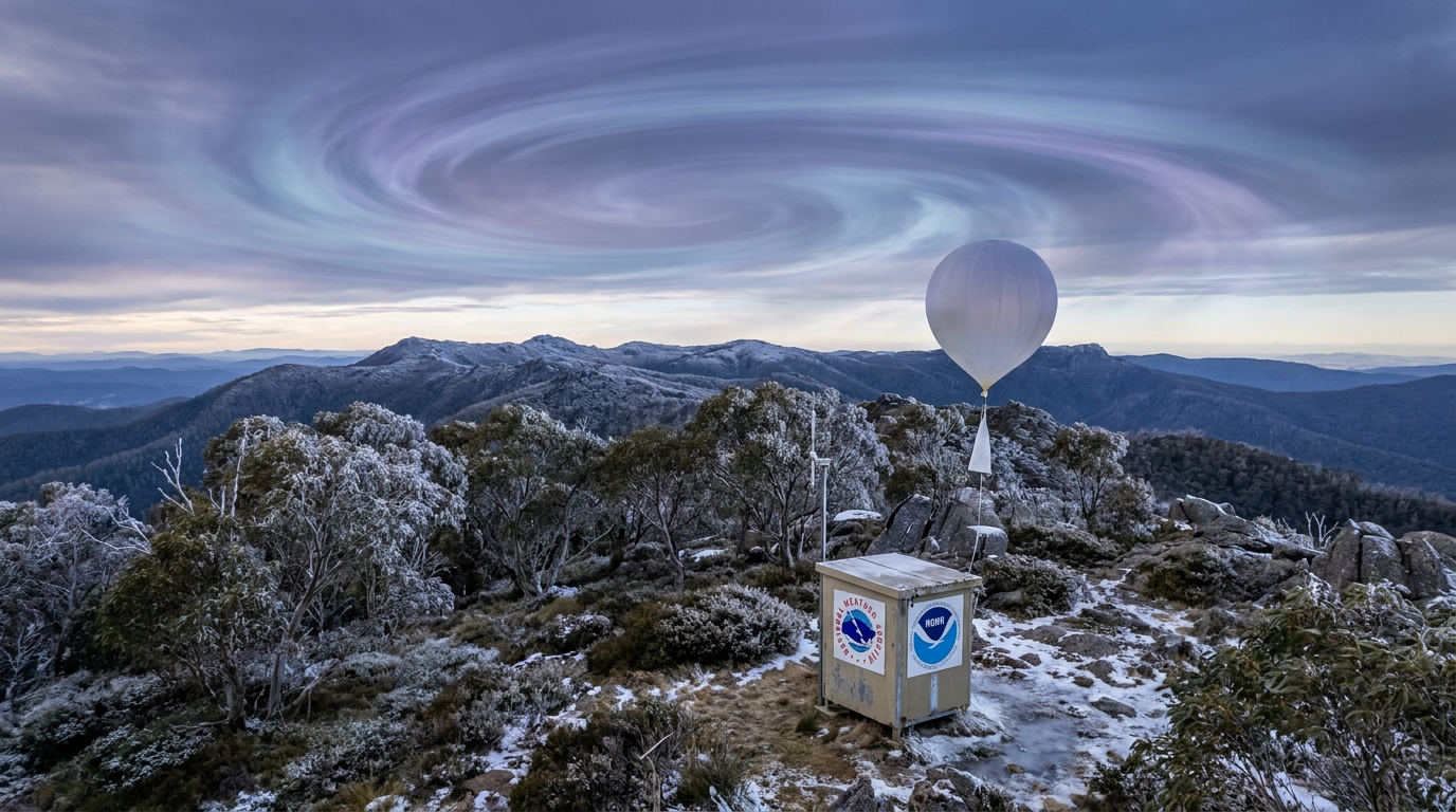
The Polar Vortex is a persistent, large-scale region of low pressure and cold air circulating high in the stratosphere above the Earth's poles. It is not a singular winter storm. Instead, it is a permanent seasonal feature that traps freezing air near the Arctic and Antarctic circles.
Key takeaways
The polar vortex is a massive circulation of cold air high in the stratosphere, not a ground-level snowstorm.
It reaches peak intensity during the dark winter months and weakens or disappears entirely during the summer.
A strong vortex keeps frigid air locked near the poles, while a weak vortex allows cold air to spill into mid-latitude regions.
Major disruptions, known as sudden stratospheric warming events, can split the winds and alter global weather patterns for weeks.
The anatomy of atmospheric circulation
Stratosphere versus troposphere
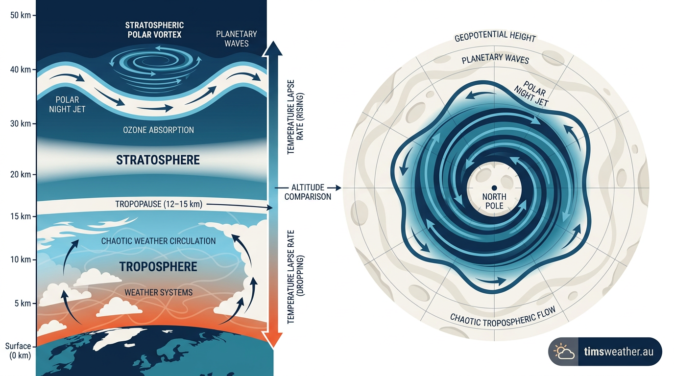
To comprehend how the atmosphere behaves, meteorologists divide it into distinct vertical layers. The weather you experience daily occurs in the troposphere, the lowest layer extending roughly 10 kilometres above the surface. Above this active zone lies the stratosphere, a highly stable layer where temperature normally increases with height because of ozone absorption. The stratospheric polar vortex exists entirely within this upper layer, circulating approximately 10 to 50 kilometres above the surface according to atmospheric profiles published by 1degreeoutside.com. Because it sits so high in the atmosphere, it does not produce rain, snow, or the surface winds associated with standard low-pressure systems. Instead, it operates as a high-altitude driver that indirectly influences the layers of the atmosphere below it over weeks or months. This is why forecasters look high above the Earth to track long-range winter weather phenomena.
What is the polar vortex?
What is the polar vortex is a question often misunderstood; it is a large-scale region of low pressure and cold air that permanently circles both the North and South Poles in the stratosphere. It is not a singular storm but a persistent atmospheric circulation pattern that, when disturbed by warming events, can push frigid air into lower latitudes.
The role of the Polar Cell and Cryosphere
Global atmospheric circulation is driven by the temperature contrast between the hot equator and the freezing poles. This contrast generates distinct circulation zones, the most northern of which is the Polar Cell. Air rises in warmer mid-latitudes and sinks over the intense cold of the Arctic Circle. The underlying ice and snow of the Cryosphere reflect solar radiation back into space, enhancing the severe cooling necessary to maintain this circulation. As the air rapidly cools during the complete darkness of the polar night, it contracts and sinks toward the surface. This creates an extensive area of intense low pressure aloft. The Earth's rotation forces the surrounding inward-flowing winds into a rapid counter-clockwise spin in the Northern Hemisphere. This intense thermal gradient is the fundamental engine that powers the main vortex structure from autumn through early spring.
The polar night jet and upper-level winds
The outer boundary of this massive cold-air pool is defined by a band of extremely fast winds known as the polar night jet. This jet stream forms the literal edge of the circulation, acting as an invisible retaining wall that keeps the coldest air locked over the pole. When the polar night jet is strong and perfectly circular, the extreme cold remains trapped, and mid-latitude regions experience relatively mild winter conditions. These winds can reach speeds exceeding 250 km/h in the upper stratosphere. However, because this jet stream is entirely dependent on the extreme temperature differences caused by polar darkness, it naturally decays and breaks down completely when sunlight returns to the Arctic in the spring. In these extreme high-altitude conditions, rare formations like polar stratospheric clouds can sometimes develop within the coldest pockets of the vortex.
Is the polar vortex a storm?
Distinguishing the stratospheric vortex from tropospheric weather patterns
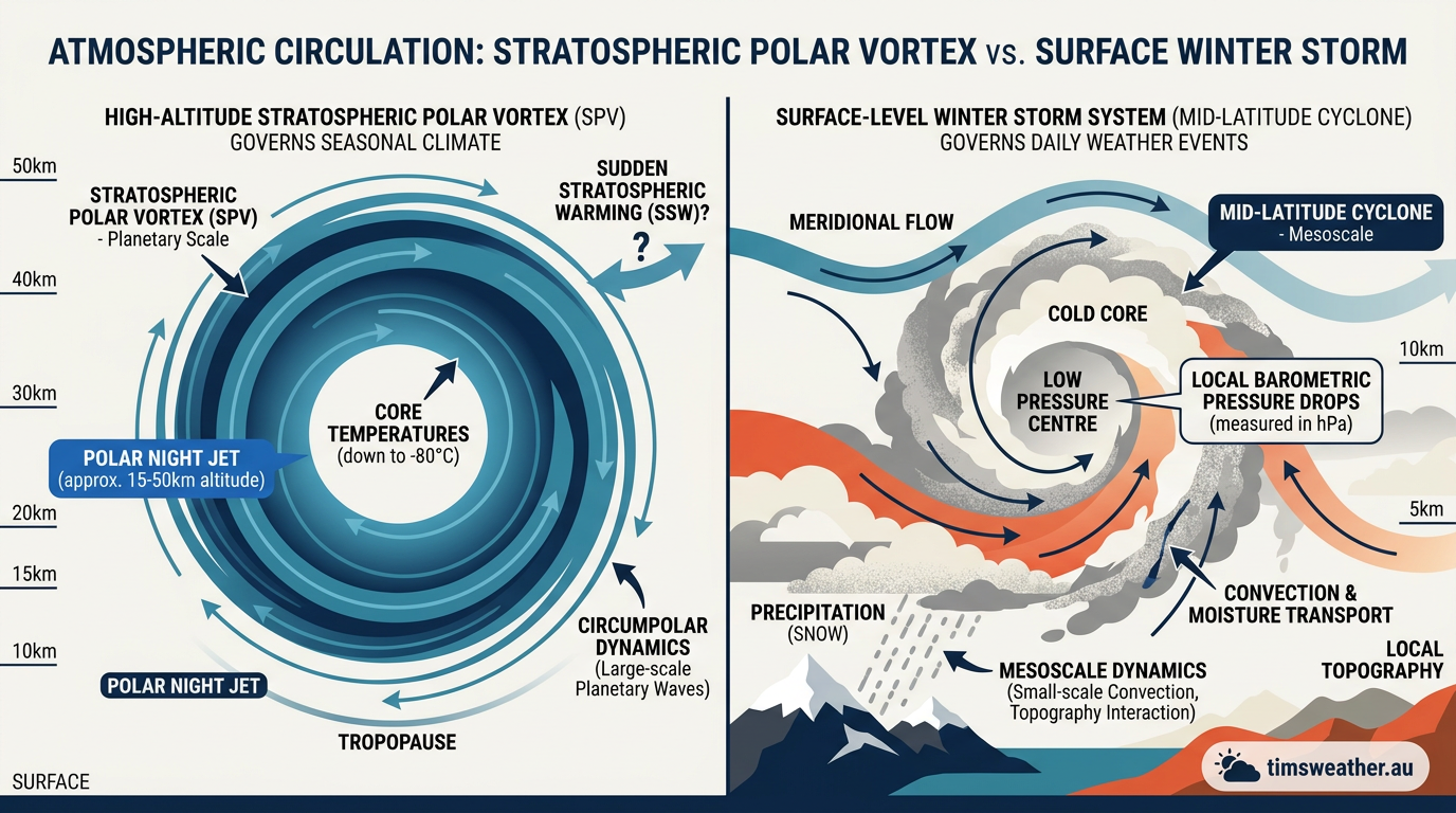
The phrase is frequently misused in public discourse to describe any severe winter weather event. However, scientific definitions separate the broad stratospheric circulation from the localized tropospheric weather systems that drop heavy snow. A true winter storm is a baroclinic cyclone forming along boundary zones between warm and cold air masses. These surface storms rely on abundant moisture and rising air to generate clouds and precipitation. In contrast, the stratospheric system is a completely dry, cold-core region devoid of precipitation. If you want to know how do blizzards form, you must look at ground-level pressure gradients, moisture transport, and local thermodynamics, not the stratosphere itself. The high-altitude winds merely supply the background cold air that a surface storm might tap into.
Feature | Stratospheric Vortex | Tropospheric Jet Stream | Weather Impact |
|---|---|---|---|
Altitude | 10 to 50 km (Stratosphere) | 8 to 12 km (Troposphere) | Drives background climate states |
Duration | Months (Autumn to Spring) | Days to weeks | Influences seasonal outlooks |
Moisture | Extremely dry | Contains abundant water vapour | Supplies precipitation for storms |
Size | Thousands of kilometres wide | Narrow ribbons of fast wind | Dictates local storm tracks |
Debunking the weather reporter myth
Media coverage often morphs complicated atmospheric mechanics into sensational buzzwords. During severe cold snaps, broadcasters sometimes claim that the main circulation has physically arrived in a specific city. This terminology is meteorologically inaccurate. The central circulation remains suspended tens of kilometres above the surface and never physically touches the ground. The widespread public confusion prompted a widely shared explanation by atmospheric scientist Dr Marshall Shepherd, who clarified that the system is a structural feature of the atmosphere, much like the equator, rather than an approaching storm front. When surface temperatures plummet rapidly, residents are experiencing an outbreak of Arctic air displaced by a weakened upper-level boundary, not the main system itself. Forecasters like Sydney Welch WX consistently remind audiences to separate the high-altitude driver from the local effects on the ground.
Polar vortex vs winter storm comparisons
Comparing these two phenomena requires looking at scale, altitude, and duration. A winter storm typically lasts three to five days, spans a few hundred kilometres across, and is driven by surface-level thermodynamics. The stratospheric winds span thousands of kilometres across the entire polar cap and persist continuously from autumn through spring. Winter storms require atmospheric lift and moisture to produce snow. The stratospheric system requires total darkness and extreme cooling to maintain its internal wind speeds. Observations cited by The Tennessean highlight that while major surface storms bring immediate disruption, the overlying upper-atmosphere dynamics are the background forces aligning the cold air. For those learning how do low-pressure systems form near the surface, the upper-level wind field acts merely as the distant container that dictates where the necessary cold air masses will eventually be positioned.
What causes polar vortex disruption?
Sudden stratospheric warming (SSW) events
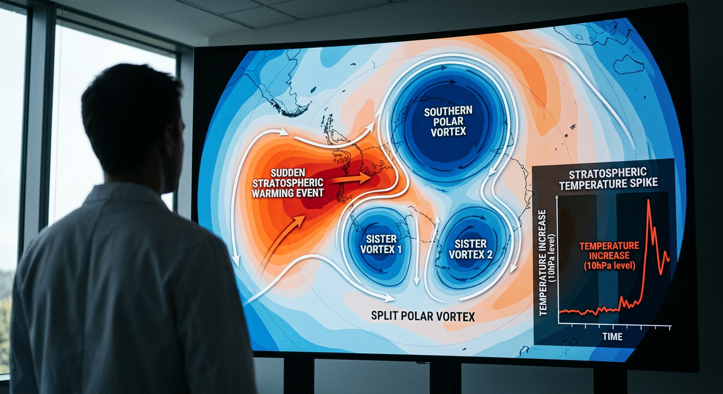
The most dramatic influence on winter weather is an event known as sudden stratospheric warming. During an SSW, temperatures in the stratosphere over the pole can spike by up to 50 degrees Celsius in just a few days. This massive injection of thermal energy reverses the typical temperature gradient, causing the strong westerly winds that contain the polar air to slow down or even reverse direction. When you examine how do sudden stratospheric warmings form, you find that they completely destabilize the atmospheric structure. Documented events, such as the major disruptions of January 2009 and January 2019, showcase how the main circulation can be knocked completely off the pole or split entirely into two smaller sister vortices. Meteorological updates, such as the Polar Vortex Breaks Down broadcast, regularly highlight these dramatic temperature reversals as the starting point for prolonged winter freezes.
The physical mechanism behind sudden stratospheric warming
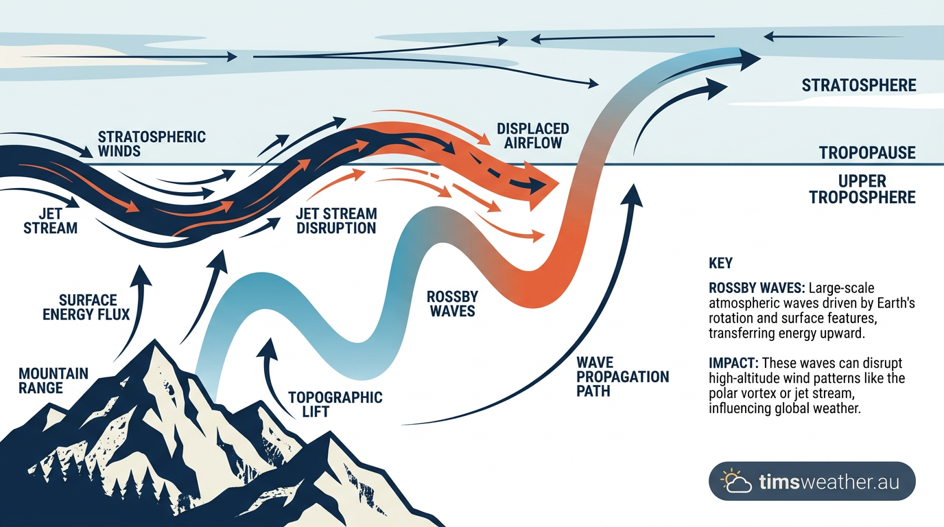
The physics behind an SSW event originate far below the stratosphere. Large mountainous regions like the Himalayas and the Rocky Mountains, combined with contrasting ocean and land temperatures, force the tropospheric wind currents to undulate vertically. These massive upward ripples of energy travel into the upper atmosphere. When these energy waves hit the highly stable stratosphere, they break, much like ocean waves crashing on a beach. The breaking waves deposit their momentum and heat directly into the core circulation, instantly warming the environment and destroying the smooth circular flow of the polar night winds. This thermal shock is what shatters the invisible barrier holding the extreme cold near the Arctic Circle.
Rossby waves and atmospheric circulation changes
These massive ripples of atmospheric energy are formally called planetary waves or Rossby waves. To understand how do Rossby waves form, one must look at the conservation of potential vorticity as air flows over major mountain ranges and follows the natural curvature of the rotating Earth. When Rossby waves remain weak, the upper-level winds remain perfectly symmetrical and centred over the pole. When Rossby waves amplify and break upward, they act as an intense braking mechanism against the high-altitude westerly winds. This wave-breaking process acts as the primary trigger for the disruptions that lead to major SSW events and subsequent extreme cold weather outbreaks down at ground level. The Antarctic vortex is generally much stronger and more stable than its Arctic counterpart precisely because the Southern Hemisphere has fewer large landmasses to generate these disruptive planetary waves.
How does the polar vortex affect weather?
Jet stream patterns and the Arctic Oscillation
The strength of the upper-level circulation heavily dictates the behaviour of the tropospheric jet stream located directly beneath it. The jet stream is a fast-moving ribbon of air that acts as a physical boundary separating freezing polar air from mild mid-latitude air. If you study how does the jet stream form, you will see it relies on intense horizontal temperature contrasts. When the high-altitude winds are strong, the jet stream is tightly constrained and flows in a relatively straight line from west to east. This aligned state is known as a positive phase of the Arctic Oscillation. As explained by KTVN News, the overarching system is an ever-present feature that simply weakens periodically. When it weakens, the Arctic Oscillation drops into a negative phase, and the jet stream becomes deeply wavy, allowing cold air to spill outward.
The North Atlantic Oscillation connection
This waviness directly interacts with regional pressure systems, particularly the North Atlantic Oscillation (NAO). The NAO governs the strength and position of the pressure gradient between the Icelandic Low and the Azores High. A disrupted stratospheric circulation frequently forces the NAO into a negative phase. During a negative NAO phase, the usual westerly winds across the Atlantic slow down, and high-pressure blocking patterns develop near Greenland. This blocks the normal progression of mild maritime air and allows freezing Arctic air to flood southward into eastern North America and western Europe. Forecasters monitor the strength of the stratospheric vortex specifically to predict these long-lasting blocking patterns.
How geopotential height anomalies drive record-breaking cold outbreaks
Meteorologists track these shifts by measuring geopotential height anomalies. They typically analyse the 10 hPa pressure level for the stratosphere and the 500 hPa level for the troposphere. A positive geopotential height anomaly over the pole indicates higher than normal atmospheric pressure and a collapsed upper-level circulation. As the winds slow down, the weakened barrier allows high pressure to build over the Arctic cap. This forces the displaced cold air southward. The downward propagation of these pressure anomalies from the stratosphere to the troposphere can take several weeks. As discussed in professional meteorology forums analyzing winter storm locations, tracking these high-altitude height anomalies allows the National Weather Service and the National Oceanic and Atmospheric Administration to forecast severe winter weather shifts long before the cold actually reaches populated mid-latitude areas.
Does the polar vortex bring extreme cold directly?
The high-altitude system itself does not bring the cold directly to your doorstep. Rather, its absence from its normal position over the pole allows the extreme cold to escape. Think of the strong upper-level winds as a high-speed corral. While the corral is intact, the coldest air on Earth stays locked up safely inside the Arctic Circle. When a sudden warming event breaks the corral, the freezing air mass spills out, flowing southward into North America, Europe, or Asia depending on exactly where the tropospheric jet stream buckles. This vast displacement of polar low pressure into mid-latitude regions is responsible for causing some of the most extreme winter weather phenomena recorded in modern history.
Explaining the polar vortex for students
The atmospheric fence analogy
A helpful way to visualise this complex atmospheric dynamic is to picture a spinning bowl of freezing water sitting on top of a table. The bowl itself represents the fast-moving stratospheric winds, and the cold water inside represents the dense, freezing Arctic air. As long as the bowl remains intact and spins quickly, the cold water stays perfectly contained. This is the normal, healthy state of the winter circulation. However, if an outside force bumps the table, the bowl wobbles. If the bump is strong enough, the bowl cracks, and the cold water spills out across the table. In the atmosphere, upward-traveling Rossby waves are the outside force bumping the table, and the spilled water represents the sudden influx of freezing air rushing southward toward populated cities.
The long-term view: climate variability and the vortex
Impact of stratospheric warming on winter seasons
The distinct lag time between a sudden stratospheric warming event and the resulting surface weather impacts provides an important window for operational forecasting. Once the stratosphere warms and the upper winds split, the resulting pressure anomalies slowly sink through the atmosphere layer by layer. It can take anywhere from ten to thirty days for the disrupted wind patterns to fully alter the tropospheric jet stream near the surface. These major events are also heavily influenced by broader global climate drivers. For instance, understanding how does El Niño form and behave in the equatorial Pacific directly impacts the global trajectory of planetary waves. Active El Niño winters can significantly enhance the atmospheric wave activity that attacks the Arctic upper atmosphere, a dynamic highlighted in detailed climate variability discussions outlining seasonal snow forecasts for the Northern Hemisphere.
Is climate change weakening the polar vortex?
The exact relationship between long-term global climate variability and the stability of these high-altitude winds is a subject of intense ongoing scientific research. As the planet warms, the Arctic region is heating at a rate nearly four times faster than the rest of the globe. This physical phenomenon, known formally as Arctic amplification, fundamentally reduces the overall temperature gradient between the hot equator and the cold North Pole. According to a detailed climate analysis by The New York Times, a drastically reduced temperature gradient between the equator and the Arctic can lead to a weaker, wobblier jet stream. This weakening allows the stratospheric cold pool to slip southward more frequently. While the core circulation remains a permanent fixture of our atmosphere, shifting global temperatures may mean that these massive disruptions will continue to shape our winter seasons in unpredictable ways for decades to come.
Sources
Climate Prediction Center (cpc.ncep.noaa.gov)
The 2018–2019 Arctic stratospheric polar vortex (repository.library.noaa.gov)
NOAA weather and atmospheric science reference (csl.noaa.gov)
Transcript For The Antarctic Stratospheric Vortex, Ozone, And Their Impact On Southeast Australian Rainfall (water.vic.gov.au)
NOAA weather and atmospheric science reference (repository.library.noaa.gov)
Bureau of Meteorology weather reference (bom.gov.au)
Bureau of Meteorology weather reference (bom.gov.au)
Bureau of Meteorology weather reference (bom.gov.au)
Last verified: 2026-09-19
Frequently asked questions
The polar vortex is a massive, persistent region of low pressure and cold air circulating around the Earth's poles. It is a natural part of the atmosphere's circulation system, not a specific storm. It typically strengthens during winter, acting to trap freezing air within the polar circle.
Further reading and resources
Explore trusted articles, books, videos and other resources to go deeper on this topic.
tennessean.comArticle
Why is the winter storm so intense? Polar vortex, moisture, jet stream align
In-depth coverage on The Polar Vortex Isn't a Storm: Here Is What It Actually Is from tennessean.com.
youtube.comVideo
The Polar Vortex Is About To UNLEASH... - YouTube
Video coverage on The Polar Vortex Isn't a Storm: Here Is What It Actually Is from youtube.com.
weather.govReference
What is the Polar Vortex? - National Weather Service
Background reference on The Polar Vortex Isn't a Storm: Here Is What It Actually Is from weather.gov.
nesdis.noaa.govReference
What Is the Polar Vortex? | NESDIS - NOAA
Background reference on The Polar Vortex Isn't a Storm: Here Is What It Actually Is from nesdis.noaa.gov.
climate.govReference
Understanding the Arctic polar vortex | NOAA Climate.gov
Background reference on The Polar Vortex Isn't a Storm: Here Is What It Actually Is from climate.gov.
nytimes.comArticle
Is Climate Change Weakening the Polar Vortex? - The New York Times
In-depth coverage on The Polar Vortex Isn't a Storm: Here Is What It Actually Is from nytimes.com.
citizen-times.comArticle
Why is the winter storm so intense? Polar vortex, moisture, jet stream align
In-depth coverage on The Polar Vortex Isn't a Storm: Here Is What It Actually Is from citizen-times.com.
pbs.orgArticle
Stretched polar vortex, moisture and a lack of sea ice all to blame for ... - PBS
In-depth coverage on The Polar Vortex Isn't a Storm: Here Is What It Actually Is from pbs.org.
wnins.comArticle
What is The Polar Vortex and How Do I Prepare My Home For It?
In-depth coverage on The Polar Vortex Isn't a Storm: Here Is What It Actually Is from wnins.com.
Planning weeks ahead?
Check Australia's long-range seasonal outlook for rainfall, temperature and the climate drivers (ENSO, IOD, SAM, MJO) shaping the next three months.
View Australia's Seasonal Weather Forecast