
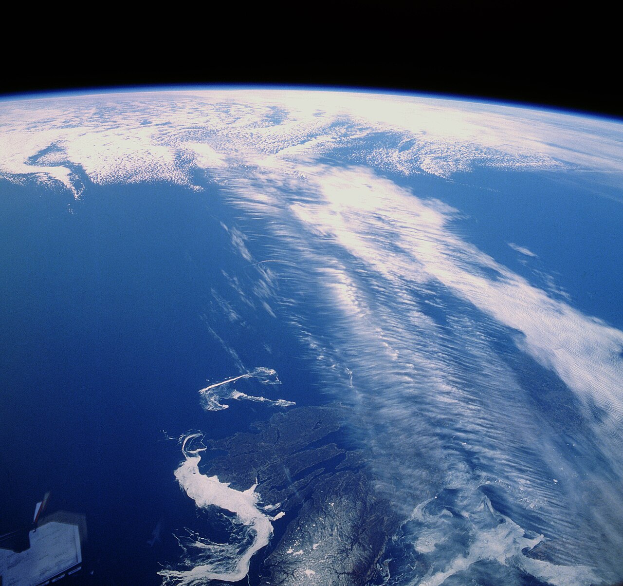
How does the jet stream form? It forms primarily through the interaction between strong latitudinal temperature gradients and the Earth's rotation. When cold polar air meets warm tropical air, the resulting pressure gradient creates strong winds, which are deflected by the Coriolis effect into concentrated, high-altitude rivers of air flowing west to east near the tropopause.
Key takeaways
Jet streams are fast-moving ribbons of air in the upper atmosphere generated by global temperature differences.
The thermal wind balance dictates that the sharpest horizontal temperature contrasts create the strongest vertical wind shear.
Earth's rotation deflects these high-altitude winds into a predominantly westerly flow, preventing air from rushing directly from high to low pressure.
The global atmospheric circulation relies heavily on the polar jet stream and the subtropical jet stream to move heat and moisture.
These atmospheric rivers steer surface weather systems, heavily influencing daily weather conditions, extreme storms, and seasonal climate patterns.
How does the jet stream form?
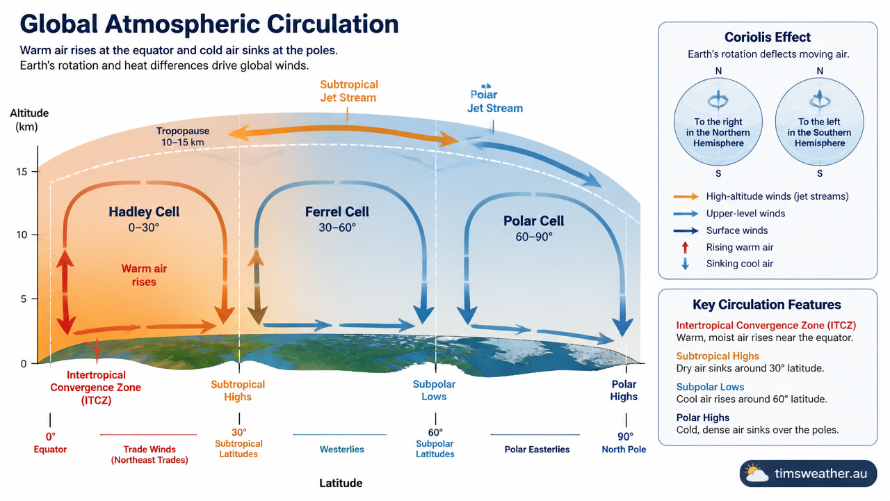
Diagram showing how does the jet stream form through global temperature differences and the Coriolis effect
At its core, understanding the mechanics behind these upper-level winds requires looking at the unequal heating of our planet. The sun warms the equatorial regions much more efficiently than it warms the poles. This uneven heating creates large masses of warm air in the tropics and cold, dense air in the polar regions. Because warm air is less dense, it expands and rises, making the atmosphere thicker at the equator than it is at the poles. High above the surface, this difference in atmospheric thickness creates a strong horizontal pressure gradient force. This force pushes air away from the higher pressure over the tropics directly toward the lower pressure over the poles.
The National Weather Service and the World Meteorological Organization define these currents as narrow bands of strong wind that generally blow from west to east. According to a summary of atmospheric mechanics by the National Oceanic and Atmospheric Administration (www.nesdis.noaa.gov), these intense winds form exactly where different air masses meet, forcing warm air to rise while cooler air sinks to replace it. The sharper the boundary between the warm and cold air, the faster the resulting winds will blow. Typical jet speeds easily exceed 108 km/h (30 metres per second or 70 mph), and can reach approximately 385 km/h (107 metres per second or 240 mph) in extreme synoptic cases.
How does the Coriolis effect influence jet stream formation?
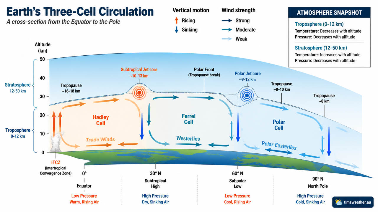
Cross-section of the atmosphere showing the troposphere dynamics and thermal wind balance driving high-altitude winds
If the Earth did not rotate, high-altitude air would flow in a straight line from the equator to the poles to balance the global heat disparity. However, the Earth's rotation introduces a phenomenon known as the Coriolis effect. As air moves poleward away from the equator, the Coriolis effect deflects it to the right in the Northern Hemisphere and to the left in the Southern Hemisphere.
By the time this high-altitude air reaches the mid-latitudes, the deflection is so strong that the air is flowing almost purely from west to east, perpendicular to the original pressure gradient. This delicate equilibrium between the pressure gradient force pushing poleward and the Coriolis effect pulling toward the equator produces a geostrophic wind. Geostrophic balance explains why upper-level winds blow zonally, circling the globe rather than moving strictly north or south.
Transitioning from geostrophic wind to concentrated currents
While geostrophic balance explains why upper-level winds blow from the west, it does not fully explain why these winds concentrate into narrow, fast-moving rivers. The actual concentration of these winds relies on a physical rule known as thermal wind balance. Thermal wind balance dictates that the vertical change in wind speed is directly proportional to the horizontal temperature gradient at the surface.
Where the temperature clash between two air masses is sharpest, the wind speeds increase dramatically as you move higher into the atmosphere. This is why the winds do not take the form of a broad, uniform flow across the whole hemisphere. Instead, they form a concentrated core of extreme winds directly above the sharpest surface temperature boundaries. When meteorology students ask how do blizzards form, the answer usually begins with the extreme baroclinic zones located directly beneath these intense upper-level wind cores.
Thermal wind balance and troposphere dynamics
To fully grasp upper-level atmospheric mechanics, meteorologists study the vertical structure of the atmosphere. The troposphere, where nearly all surface weather occurs, is not a uniform dome. It is highly structured by global circulation systems that dictate exactly where temperature gradients become steep enough to generate high-speed winds aloft.
Global atmospheric circulation cells
The Earth's atmospheric circulation is generally modelled as three primary cells in each hemisphere: the Hadley cell near the equator, the Ferrel cell in the mid-latitudes, and the Polar cell near the poles. As noted in a meteorological glossary compiled by atmospheric data experts (www.cordulus.com), jet streams are intimately associated with the boundaries between these main atmospheric circulation cells.
Within the Hadley cell, air rises at the equator, moves poleward at high altitudes, and then sinks near 30 degrees latitude. The Ferrel cell is an indirect circulation driven by the movement of the adjacent cells, forcing air toward the poles at the surface and toward the equator aloft. The Polar cell features cold air sinking at the poles and moving toward the mid-latitudes. The boundaries where these large-scale cells collide are areas of intense thermal contrast. The rising and sinking motions along these boundaries create the steep pressure gradients aloft necessary to fuel extreme wind speeds. How this macro-scale sinking air is essential when exploring how do high-pressure systems form near the surface.
Video: The polar jet stream can reach speeds exceeding 100 mph. In this visualization, the strongest winds are shown in red, while slower winds appear in blue. Video courtesy of NASA’s Scientific Visualization Studio. https://svs.gsfc.nasa.gov/
The role of the tropopause in concentrating wind speeds
These fast-moving currents are typically located in the upper troposphere, just below the tropopause. The tropopause is the transition boundary separating the active weather of the troposphere from the highly stable, dry stratosphere above it. Because the troposphere is thicker in warm equatorial regions and thinner in cold polar regions, the tropopause slopes downward toward the poles.
Importantly, the tropopause is not a continuous, smooth layer. It features distinct breaks or vertical steps exactly where the main atmospheric circulation cells meet. The core of the highest winds usually sits within these tropopause breaks. In these gaps, stratospheric air occasionally folds downward into the troposphere, bringing high ozone concentrations and extremely dry air into mid-latitude weather systems. How this vertical structure is necessary when forecasters determine how do cold fronts form and how they interact with upper-level dynamics.
What is the difference between the polar jet and the subtropical jet?
While there are many minor wind bands in the atmosphere, global meteorology primarily tracks two main currents in each hemisphere. Knowing how these two wind bands differ is essential for forecasting both daily weather and seasonal climate patterns.
The polar front jet
The polar jet sits directly above the polar front, which is the dividing line between cold polar air and warmer mid-latitude air. Because the horizontal temperature contrast across the polar front is often severe, especially in winter, this upper-level wind is highly dynamic. Geoscience texts exploring general circulation models (geo.libretexts.org) indicate that the polar jet generally sits near 50 to 60 degrees latitude at an altitude of approximately 10 kilometres.
This wind band is the primary driver of mid-latitude storm tracks. It is highly variable, frequently meandering north and south. When a common question arises regarding how do low-pressure systems form, meteorologists look straight to the polar front jet. The divergence of air in the upper levels of this current acts like a vacuum, removing mass from the atmospheric column and forcing surface pressure to drop rapidly. Observers tracking Australian air masses often see this exact interaction trigger deep southerly low-pressure systems in winter.
The subtropical jet stream
Closer to the equator lies the subtropical jet stream. This current forms near the poleward descending branch of the Hadley cell, typically around 25 to 35 degrees latitude. Because the tropopause is higher over the tropics, the subtropical jet is located at a higher altitude, usually around 13 to 15 kilometres above the surface.
Unlike the polar jet, which is primarily driven by sharp surface temperature boundaries (baroclinic zones), the subtropical jet is heavily influenced by the conservation of angular momentum. As air rises at the equator and moves poleward high in the troposphere, it moves closer to the Earth's axis of rotation. To conserve angular momentum, the air must speed up, creating a fast-moving westerly current. The subtropical jet is generally more continuous and less wavy than its polar counterpart.
Jet Stream Type | Formation Mechanism | Typical Altitude | Primary Influence |
|---|---|---|---|
Polar Front Jet | Surface temperature gradients (Thermal wind balance) | 8 to 11 kilometres | Steering mid-latitude storms and blizzards |
Subtropical Jet | Angular momentum and Hadley cell boundary | 12 to 15 kilometres | Moisture transport and atmospheric blocking |
Tropical Easterly Jet | Summer heating over continental landmasses | 14 to 16 kilometres | Modulating Asian and African monsoon seasons |
Polar Night Jet | Extreme cooling during polar winter darkness | 24 kilometres (Stratosphere) | Driving the stratospheric polar vortex |
Why does the jet stream change position seasonally?
The location and intensity of these upper-level winds are never static. They shift continuously in response to the changing seasons, ocean surface temperatures, and large-scale atmospheric oscillations.
How seasonal temperature gradients shift jet stream paths
During the winter months, the hemisphere tilted away from the sun experiences a drastic drop in temperatures at the pole, while the equatorial regions remain relatively warm. This deepens the latitudinal heat imbalance, creating a much steeper horizontal temperature gradient across the mid-latitudes. As the laws of thermal wind balance dictate, a stronger temperature gradient produces stronger upper-level winds.
Consequently, the core of the strongest winds expands and shifts closer to the equator during winter, driving powerful storm systems deep into populated mid-latitude zones. In the summer months, as the polar regions warm and the ice recedes, the temperature contrast weakens. The winds subsequently slow down and retreat poleward, often leaving the mid-latitudes with weaker synoptic forcing and more isolated, heat-driven weather patterns. This seasonal retreat heavily dictates how do single-cell thunderstorms form in summer environments versus highly organised storm systems in winter.
Rossby waves and meridional flow
Rather than flowing in a straight line, these currents constantly meander north and south in massive loops known as Rossby waves. A review of global weather mechanics (watchers.news) highlights that these planetary waves allow cold polar air to spill toward the equator into deep troughs, while simultaneously drawing warm tropical air poleward into high ridges.
When the flow is highly zonal (moving straight from west to east), weather systems move rapidly across the continent, bringing quickly changing but generally moderate weather. However, when the flow becomes highly meridional (wavy, moving north to south), weather systems can stall in place. This atmospheric blocking leads to prolonged periods of heavy rain, extreme heatwaves, or deep freezes, depending on whether a region is trapped under a ridge or a trough.
The impact of upper-level winds on global weather
Beyond defining broad climate zones, these upper-tropospheric currents actively dictate daily surface weather conditions. They interact dynamically with low-pressure systems, moisture fields, and topography to create major weather events.
Jet streaks and baroclinic instability
Within the broader river of air, there are localized zones of maximum wind speed known as jet streaks. Air physically accelerates as it enters a jet streak and decelerates as it exits. This speeding up and slowing down forces air to converge and diverge in specific quadrants of the streak. Identifying these upper-level dynamic zones is a primary step when forecasting how do warm fronts form beneath intense mid-latitude cyclones.
An explainer on regional weather patterns (www.news9.com) illustrates that these high-speed wind corridors dictate where severe surface storms initiate. When the left-exit or right-entrance regions of a jet streak pass over an area, they create massive divergence aloft. This pulls air rapidly up from the surface. If this forced ascent aligns with a moist, unstable surface environment, the rapid lift can trigger widespread severe thunderstorms, tornadoes, and squall lines.
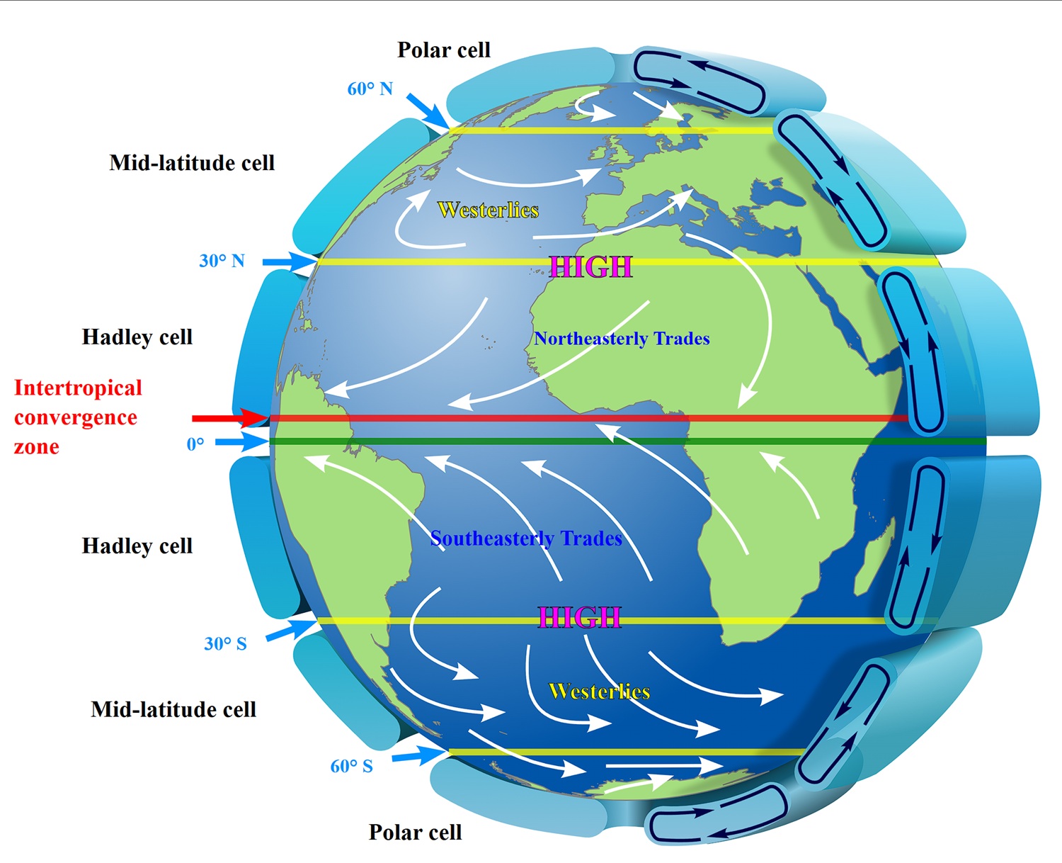
Highly idealised depiction of the global circulation. The upper-level jets tend to flow latitudinally along the cell boundaries. By Kaidor, CC BY-SA 3.0, https://commons.wikimedia.org/w/index.php?curid=23902538
Steering storm systems and tropical cyclones
The position of the subtropical jet plays a highly significant role in tropical meteorology. When researchers study how do tropical cyclones form, they must account for vertical wind shear. If a nascent tropical depression encounters the intense upper-level winds of a jet current, the storm's vertical cloud structure can be torn apart, inhibiting further development. Likewise, before understanding how do hurricanes form in the Atlantic basin, meteorologists measure the strength of the subtropical westerly winds directly above the developing wave.
Conversely, mature tropical cyclones are often steered by the flow around upper-level troughs extending from the main westerly wind band. In some cases, the divergence of air aloft ahead of an advancing mid-latitude trough can act like a chimney for a tropical cyclone, helping to vent the storm outward at the top and allowing its central pressure to drop further.
Long-term shifts and climate variability
Modern climate data indicates that the position and behaviour of these currents are changing over time. According to a spatio-temporal analysis of atmospheric dynamics published in the National Library of Medicine (pmc.ncbi.nlm.nih.gov), observational data from 1984 to 2023 shows notable shifts in jet trajectories. The analysis reveals a measurable poleward shift and increased variability in zonal wind speeds, particularly over the North Pacific Ocean.
Regional variations are also highly impactful. For instance, observations of United Kingdom weather systems (www.quora.com) demonstrate that when the polar jet stream moves north, it typically draws in high pressure and drier conditions, whereas a southern shift brings persistent low-pressure and wet weather. As global temperature gradients change due to polar warming, many meteorologists suggest this could lead to a wavier, more unpredictable meridional flow globally, causing weather systems to stall more frequently.
Frequently asked questions
The jet stream forms where strong temperature contrasts between warm and cold air masses create a sharp pressure gradient high in the atmosphere. Earth’s rotation, through the Coriolis effect, bends this flow, concentrating it into fast, narrow bands of westerly winds located in the upper troposphere near the tropopause.
Source: nesdis.noaa.gov
Further reading and resources
Explore trusted articles, books, videos and other resources to go deeper on this topic.
youtube.comVideo
What Is the Jet Stream? - YouTube
Video coverage on How does the jet stream form? from youtube.com.
education.nationalgeographic.orgArticle
Jet Stream - National Geographic Education
In-depth coverage on How does the jet stream form? from education.nationalgeographic.org.
skybrary.aeroArticle
Jet Stream | SKYbrary Aviation Safety
In-depth coverage on How does the jet stream form? from skybrary.aero.
en.wikipedia.orgReference
Jet stream - Wikipedia
Background reference on How does the jet stream form? from en.wikipedia.org.
eoas.ubc.caArticle
Jet Streams and Mid-latitude Systems - UBC EOAS
In-depth coverage on How does the jet stream form? from eoas.ubc.ca.
climate.govReference
What is the jet stream? | NOAA Climate.gov
Background reference on How does the jet stream form? from climate.gov.
study.comArticle
Jet Streams & Polar Front | Definition & Causes - Lesson - Study.com
In-depth coverage on How does the jet stream form? from study.com.
skepticalscience.comArticle
A Rough Guide to the Jet Stream
In-depth coverage on How does the jet stream form? from skepticalscience.com.
nesdis.noaa.govReference
What Is the Jet Stream? | NESDIS
Background reference on How does the jet stream form? from nesdis.noaa.gov.
noaa.govReference
The Jet Stream | National Oceanic and Atmospheric ...
Background reference on How does the jet stream form? from noaa.gov.
Planning weeks ahead?
Check Australia's long-range seasonal outlook for rainfall, temperature and the climate drivers (ENSO, IOD, SAM, MJO) shaping the next three months.
View Australia's Seasonal Weather Forecast