

If you are wondering why bomb cyclones explode, the answer lies in explosive cyclogenesis. This process occurs when an extratropical cyclone experiences a surface pressure drop of at least 24 millibars within 24 hours. The rapid intensification is driven by extreme temperature contrasts and strong upper-level jet stream divergence.
Key takeaways
In 1980, a landmark study first coined the term 'bomb' for severe maritime storms that intensify with extreme speed.
The rapid intensification is powered by baroclinic instability, where cold continental air clashes violently with warm ocean air.
Upper-level winds and jet stream divergence act as an atmospheric exhaust system, removing air aloft faster than it can accumulate at the surface.
Unlike tropical systems powered entirely by latent heat, bomb cyclones derive their primary energy from sharp horizontal temperature gradients.
The Science Behind Why Bomb Cyclones Explode
Extratropical cyclones rely on colliding air masses and powerful upper-level winds to drive their rapid intensification. When these meteorological ingredients align perfectly, a standard winter storm can morph into a dangerous, fast-moving system with hurricane-force wind gusts and massive offshore waves.
The foundational understanding of explosive cyclogenesis mechanics dates back to a landmark 1980 study by meteorologists Frederick Sanders and John Gyakum. They sought to categorise severe maritime storms that deepened so rapidly they caught commercial shipping vessels completely off guard. By analysing historical data and surface pressure charts, they coined the term "bomb" for any low-pressure system that met a specific, extreme rate of atmospheric pressure decline.
Today, the World Meteorological Organization and national forecasting agencies use their original criteria to identify atmospheric bomb cyclone formation globally. The structural evolution of these intense storms is closely monitored using satellite meteorology, which allows forecasters to see the distinctive comma-shaped cloud shields developing in real time before the system impacts coastal communities.
Why do bomb cyclones explode in intensity?
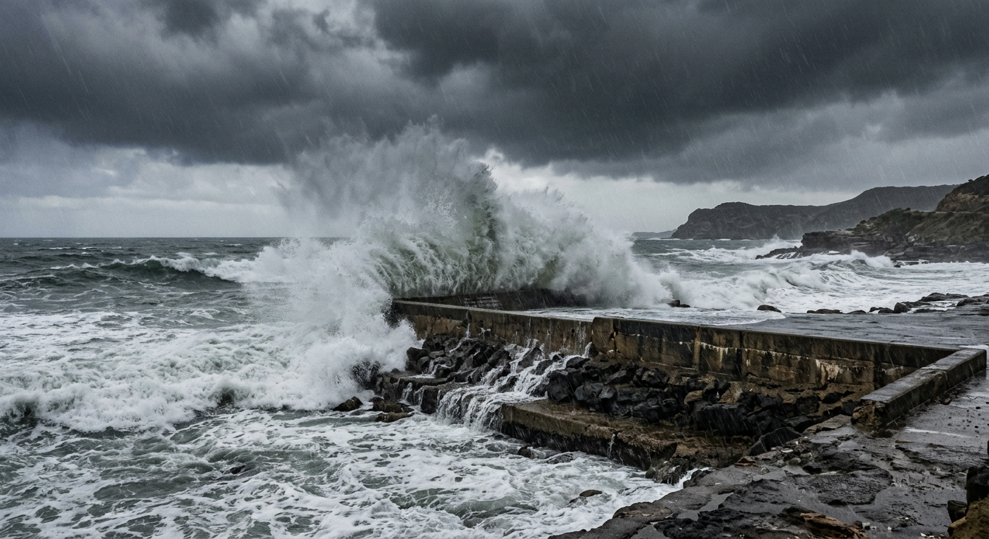
Why bomb cyclones explode is rooted in the process of explosive cyclogenesis, where an extratropical cyclone experiences a surface pressure drop of at least 24 millibars within 24 hours. This rapid intensification occurs due to intense baroclinic instability, where strong horizontal temperature gradients and upper-level jet stream divergence trigger sudden atmospheric destabilization.
Identifying Atmospheric Bomb Cyclone Formation
To confirm that a storm is undergoing rapid intensification, meteorologists rely on a combination of surface observations and numerical weather prediction models. Forecasters regularly analyse real-time NOAA GFS or ECMWF model output to track the tightening of isobars around the storm centre. These models help predict exactly when the surface pressure drop in cyclones will reach its maximum rate, giving emergency services critical lead time to issue severe weather warnings.
Cyclone Deepening Rates and the Bergeron Threshold
Not every deep low-pressure system qualifies as a bomb cyclone. To earn the official classification, a storm must meet strict mathematical criteria that measure the speed of its intensification rather than just its final minimum pressure. This rapid rate of change is the definitive signature of a true weather bomb.
The Bergeron Scale: How Meteorologists Classify Cyclone Explosivity
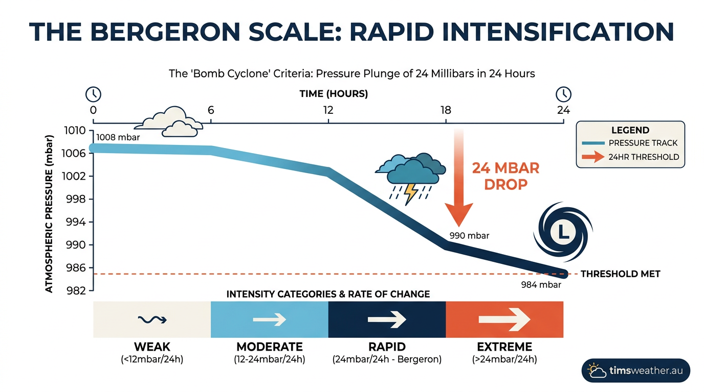
The standard benchmark for explosive cyclogenesis is a drop in central pressure of 24 millibars (or hectopascals) over a 24-hour period. However, this simple standard is technically only accurate at 60 degrees latitude. Sanders and Gyakum created a mathematical measurement called the Bergeron scale to account for the Coriolis effect, which varies based on the distance from the equator.
Because the Coriolis force is weaker closer to the equator, the required pressure drop to achieve geostrophic wind balance is lower at middle latitudes. For example, at 45 degrees latitude, a pressure drop of roughly 17 to 18 millibars in 24 hours is sufficient to classify a system as a bomb cyclone. Meteorologist Grant Gilmore notes that this specific, rapid pressure decrease indicates a violently strengthening storm capable of producing extreme surface hazards (NEXT Weather).
Latitude Adjustments and Geostrophic Wind
The relationship between pressure drops and wind speed is dictated by geostrophic wind principles. As atmospheric pressure plummets rapidly in the centre of the cyclone, surrounding air rushes in to fill the void. The steeper the pressure gradient becomes over a short distance, the faster the winds blow. The Bergeron threshold ensures that the classification accurately reflects this severe wind threat, regardless of whether the storm forms off the coast of New England or over the open North Pacific.
Atmospheric Dynamics: How Winds Aloft Drive Surface Storms
The rapid intensification of cyclones cannot be explained by surface conditions alone. The true engine of explosive cyclogenesis sits high in the troposphere, where high-speed ribbons of air dictate the movement and intensity of weather systems below.
The Role of Jet Stream Interaction in Cyclone Deepening Rates
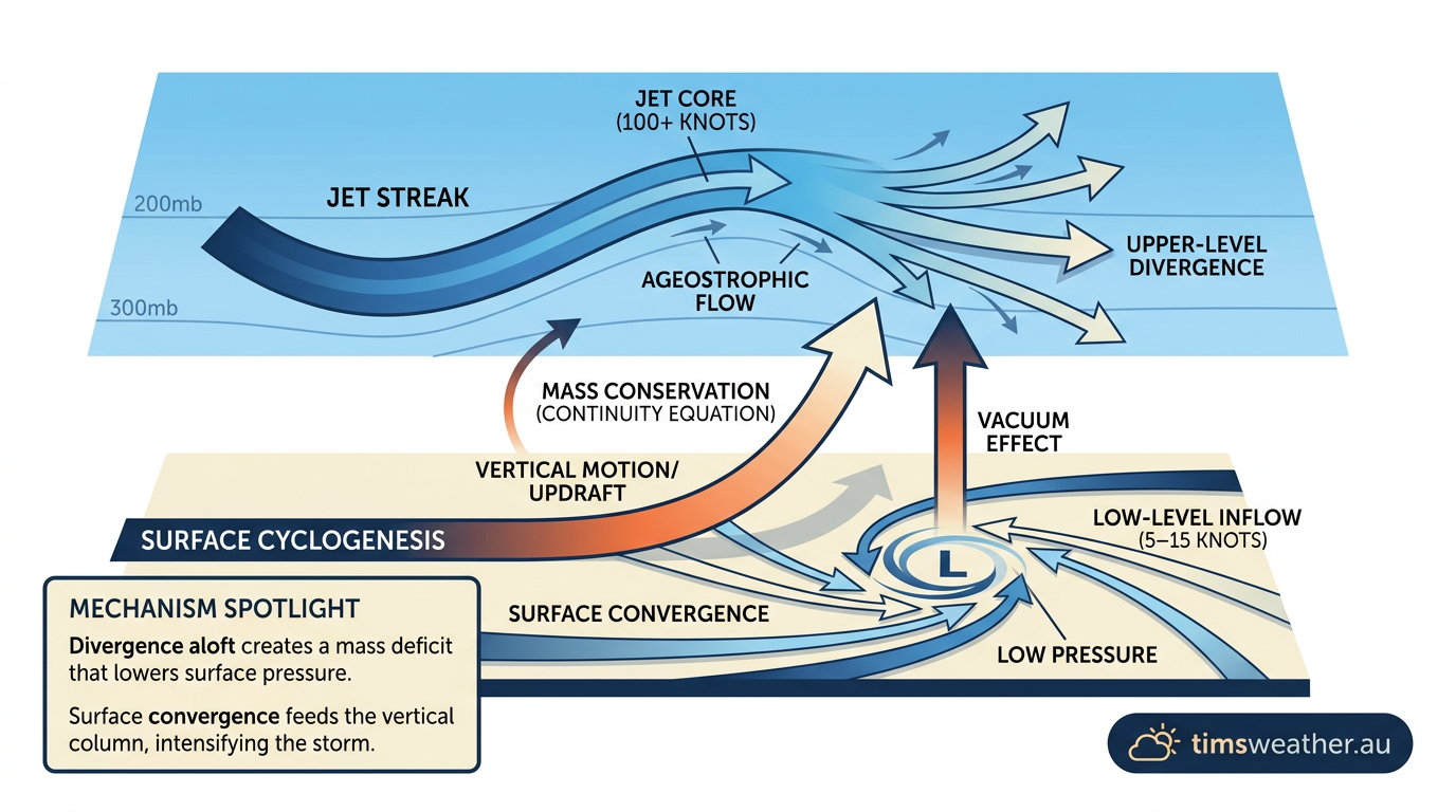
The physical link between upper-level troughs and lower-level surface cyclogenesis is governed by a concept known as divergence. When a strong jet stream flows overhead, it often contains concentrated pockets of maximum wind speed known as jet streaks. As air accelerates into and out of these streaks, it creates areas where air spreads apart, or diverges, high in the atmosphere.
If this upper-level jet stream divergence is positioned directly above a surface low-pressure system, it acts like a massive atmospheric vacuum. It removes mass from the top of the air column faster than surface winds can converge to replace it below. This mass deficit forces the surface pressure drop to accelerate violently.
Rossby Waves and Upper-Level Troughs
The entire interaction is further amplified by Rossby waves, which are large meandering loops in the upper-atmospheric flow. When deep upper-level troughs holding immense potential vorticity cross over strong surface temperature boundaries, the atmosphere becomes highly unstable. The spin from the upper atmosphere stretches downward, forcing the surface cyclone to deepen at a remarkable rate.
Temperature Gradients and Moisture Fuel
While upper-level divergence provides the exhaust mechanism, the storm still requires a massive fuel source to maintain its violent spin. In extratropical systems, this energy comes from extreme temperature contrasts rather than a uniformly warm ocean surface.
The Thermodynamics of Surface Pressure Drop in Bomb Cyclones
Baroclinic instability in cyclones occurs when dense, cold continental air clashes violently with warm, moist oceanic air along a sharp boundary known as a baroclinic zone. As strong cold fronts push beneath the warmer marine air, the less dense warm air is forced to rise rapidly. This vertical motion converts potential energy into kinetic energy, spinning the storm up at an explosive rate.
Latent heat release also plays a significant secondary role. As the storm pulls in moisture from high sea surface temperatures, the water vapour condenses into intense bands of rain and snow. This condensation process releases latent heat directly into the core of the storm. The added heat lowers the density of the air column further, creating a feedback loop that accelerates the surface pressure drop (PBS NewsHour).
The Secondary Role of Sea Surface Temperature
Although horizontal temperature differences are the primary driver, anomalously warm sea surface temperatures offshore can dramatically enhance bombogenesis. Warm ocean currents, such as the Gulf Stream in the Atlantic or the Kuroshio Current in the Pacific, act as vast reservoirs of heat and moisture. When an Arctic air mass passes over these currents, the extreme thermal contrast triggers rapid destabilization from the surface upward.
Contrasting Extratropical and Tropical Storm Systems
Because bomb cyclones often produce hurricane-force wind gusts, torrential rain, and devastating storm surge, they are frequently compared to hurricanes and typhoons. However, the meteorological architecture of these two storm types is completely different.
Comparing Tropical Cyclone Intensification vs. Explosive Cyclogenesis
The fundamental difference lies in their primary energy source. Tropical cyclones are warm-core systems that thrive in environments with low vertical wind shear. They derive their energy almost entirely from the latent heat released by warm ocean waters near the equator. In contrast, extratropical cyclones development relies on high vertical wind shear and the baroclinic energy provided by horizontal temperature gradients.
While the National Hurricane Center tracks tropical development in the Atlantic and Eastern Pacific, the broader National Weather Service monitors explosive cyclogenesis events in higher latitudes. Both storm types are highly destructive, but they require entirely distinct atmospheric conditions to form and mature (The Weather Channel).
Process Type | Pressure Change Threshold | Primary Energy Source | Cyclone Classification |
|---|---|---|---|
Explosive Cyclogenesis | ≥24 hPa drop in 24 hours | Temperature gradients (Baroclinic) | Extratropical Bomb Cyclone |
Rapid Intensification | ≥30 knots wind increase in 24 hours | Latent heat from oceans (Barotropic) | Tropical Cyclone / Hurricane |
Standard Extratropical | <24 hPa drop in 24 hours | Temperature gradients (Baroclinic) | Mid-latitude Low |
The Lifecycle of Atmospheric Bomb Cyclone Formation
The development of a bomb cyclone follows a specific sequence of events known in synoptic meteorology as the Norwegian Cyclone Model, though accelerated to an extreme degree. How these stages unfold is essential for meteorologists trying to predict exactly when and where a system will "bomb out" and impact populated coastlines.
Initial Phase and the Baroclinic Zone
The process begins with an initial wave along a stationary front, where cold and warm air masses flow in opposite directions. As an upper-level disturbance approaches, surface pressures begin to fall slowly. At this stage, a warm front develops ahead of the low-pressure centre, while a cold front trails behind it, initiating the cyclonic circulation.
The Explosive Deepening Phase
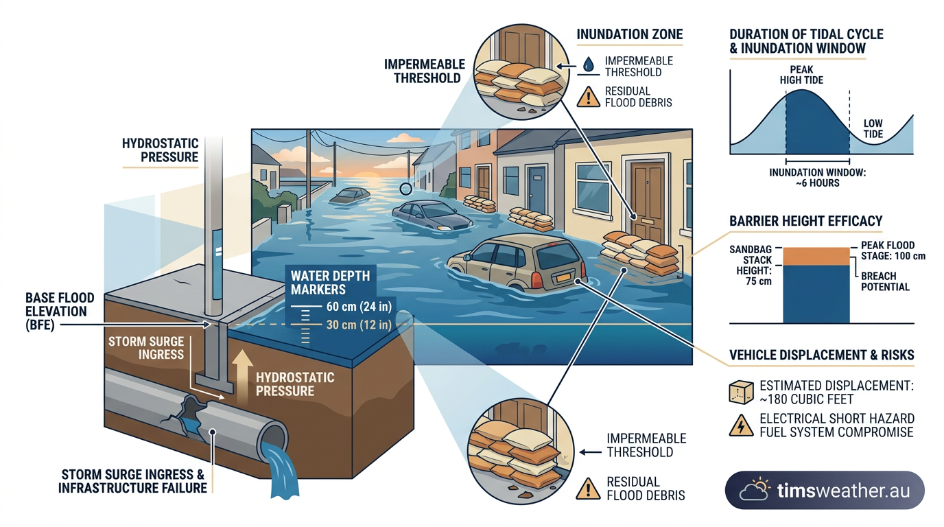
The important second stage is the deepening phase. Over a period of 12 to 24 hours, the central pressure plummets as the cold front wraps rapidly around the low centre. This is when the strongest pressure gradients form, generating destructive winds. During this phase, precipitation rates peak, often leading to severe coastal flooding or conditions that trigger heavy blizzards if the air is cold enough.
The Occluded Stage and Peak Intensity
Finally, the cyclone enters the occluded stage. The faster-moving cold front overtakes the warm front, cutting off the storm's supply of warm, moist air from the surface. The storm reaches its absolute peak intensity here before beginning to slowly spin down. In a bomb cyclone, this entire lifecycle happens so fast that forecasters often have a narrow window to issue life-saving warnings.
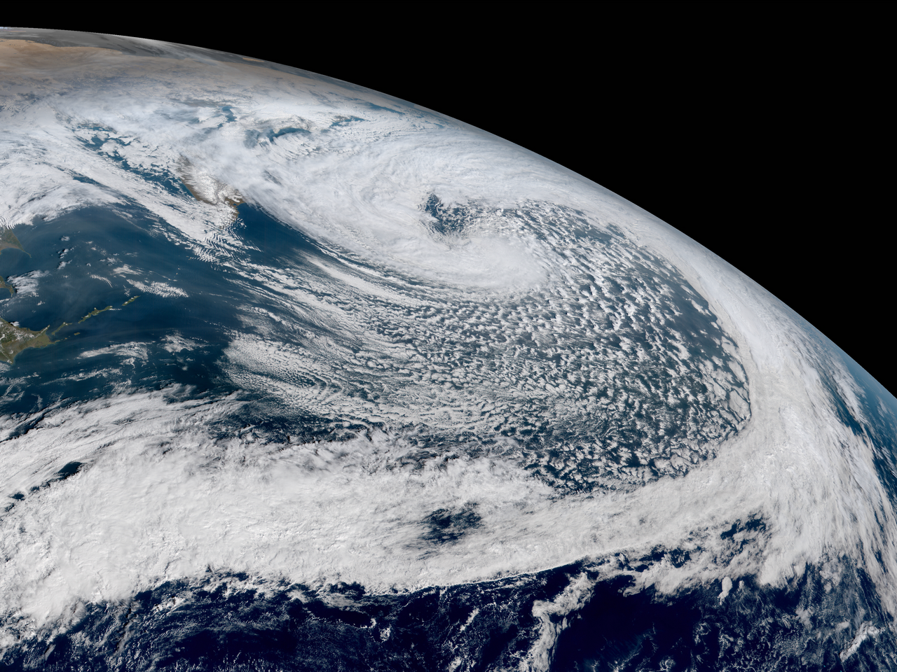
Global Storm Tracks and Historical Events
Explosive cyclogenesis is most common during late autumn and winter when the temperature difference between freezing landmasses and relatively warm ocean currents is at its absolute peak. By analysing historical IBTrACS data, meteorologists have identified specific global storm tracks where these extreme systems are most likely to develop.
The Northwest Atlantic and North Atlantic Oscillation
The Northwest Atlantic is a primary breeding ground. Here, freezing continental air from North America regularly sweeps off the coast and collides with the warm waters of the Gulf Stream. A famous example is the "Perfect Storm" of 1991, which underwent rapid deepening and caused severe coastal impacts. The broader atmospheric pattern, including the North Atlantic Oscillation, often dictates whether these storms track heavily towards Europe or remain out over the open ocean.
Pacific Northwest and Recent Bomb Cyclones
The Northwest Pacific is equally active, driven by cold air from Siberia meeting the warm Kuroshio Current. The Eastern Pacific also sees significant explosive events. In November 2024, a powerful bomb cyclone struck the Pacific Northwest, generating hurricane-force winds and heavy snow that resulted in fatalities and widespread power outages across the region (KING5 News). These fast-moving winter storms regularly pose severe coastal flooding and infrastructure threats to mid-latitude regions, particularly across Canada and the northern United States (EcoFlow).
Winter Storms and High-Impact Coastal Events
Recent years have seen highly publicised events worldwide. In Europe, Storm Éowyn in January 2025 drew intense scientific analysis regarding its explosive cyclogenesis mechanics and high-impact wind fields. Similarly, in January 2026, forecasters closely tracked Storm Gianna as it rapidly intensified into a bomb cyclone off the US East Coast, bringing heavy snow and coastal flooding to areas still recovering from previous severe winter storms (The Columbus Dispatch). The hazardous conditions created by these fast-moving systems highlight the critical need for advanced meteorological tracking and early public warnings globally.
Sources
NOAA weather and atmospheric science reference (ncei.noaa.gov)
World Meteorological Organization weather reference (wmo.int)
cyclone.wmo.int PDF reference (cyclone.wmo.int)
ERIN Graphics Archive: <br> Initial Wind Field and Watch/Warning Graphic (nhc.noaa.gov)
ERDDAP - IBTrACS, International Best Track Archive for Climate Stewardship, version v04r00, Last Three Years (erddap.aoml.noaa.gov)
2006 - Albany CSTAR - Virtual Lab (vlab.noaa.gov)
Remembering the “Perfect Storm” - National Weather Service Heritage (vlab.noaa.gov)
The Halloween Storm, Also Known as "The Perfect Storm" (nesdis.noaa.gov)
Last verified: 2026-09-21
Frequently asked questions
A bomb cyclone is a mid-latitude storm system that intensifies rapidly. It occurs when atmospheric pressure drops by at least 24 millibars within 24 hours. This explosive deepening happens because of strong temperature contrasts between colliding cold and warm air masses, which fuels the storm's growth and destructive potential.
Source: pbs.org
Further reading and resources
Explore trusted articles, books, videos and other resources to go deeper on this topic.
ebsco.comArticle
Explosive cyclogenesis | Environmental Sciences - EBSCO
In-depth coverage on Why Bomb Cyclones Explode: Inside Explosive Cyclogenesis from ebsco.com.
metoffice.gov.ukReference
Weather bombs: What causes explosive cyclogenesis? - Met Office
Background reference on Why Bomb Cyclones Explode: Inside Explosive Cyclogenesis from metoffice.gov.uk.
scied.ucar.eduReference
What Makes a Bomb Cyclone - UCAR Center for Science Education
Background reference on Why Bomb Cyclones Explode: Inside Explosive Cyclogenesis from scied.ucar.edu.
midmichigannow.comArticle
Bomb Cyclones Explained
In-depth coverage on Why Bomb Cyclones Explode: Inside Explosive Cyclogenesis from midmichigannow.com.
en.wikipedia.orgReference
Explosive cyclogenesis - Wikipedia
Background reference on Why Bomb Cyclones Explode: Inside Explosive Cyclogenesis from en.wikipedia.org.
quora.comArticle
How do you explain bomb cyclone in simple terms and relative to other ...
In-depth coverage on Why Bomb Cyclones Explode: Inside Explosive Cyclogenesis from quora.com.
pacificflying.comArticle
What are Bomb Cyclones - Pacific Flying Club
In-depth coverage on Why Bomb Cyclones Explode: Inside Explosive Cyclogenesis from pacificflying.com.
kneedeeptimes.orgArticle
What Exactly is a Bomb Cyclone Anyway? - KneeDeep Times
In-depth coverage on Why Bomb Cyclones Explode: Inside Explosive Cyclogenesis from kneedeeptimes.org.
skybrary.aeroArticle
Explosive Cyclogenesis | SKYbrary Aviation Safety
In-depth coverage on Why Bomb Cyclones Explode: Inside Explosive Cyclogenesis from skybrary.aero.
journals.ametsoc.orgArticle
Explosive Cyclogenesis over the Eastern United States in
In-depth coverage on Why Bomb Cyclones Explode: Inside Explosive Cyclogenesis from journals.ametsoc.org.
Planning weeks ahead?
Check Australia's long-range seasonal outlook for rainfall, temperature and the climate drivers (ENSO, IOD, SAM, MJO) shaping the next three months.
View Australia's Seasonal Weather Forecast