
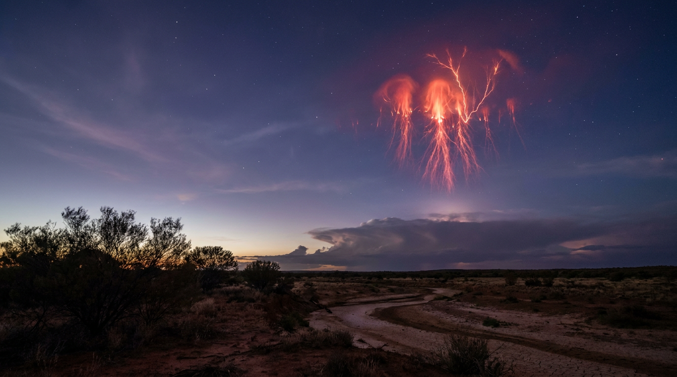
Red sprites lightning refers to large-scale, high-altitude electrical discharges that occur in the mesosphere above active thunderstorms. These transient luminous events are triggered by intense positive cloud-to-ground lightning strikes, which create a massive electrical imbalance that ionises the atmosphere at altitudes of 50 to 90 kilometres.
Key takeaways
Red sprites appear as faint, reddish flashes high above active thunderstorm systems, lasting only a few milliseconds.
These atmospheric phenomena occur in the mesosphere at altitudes between 50 and 90 kilometres, making them difficult to observe from the ground.
They are directly triggered by intense positive cloud-to-ground lightning strikes that disrupt the upper-atmospheric electric field.
High-speed cameras and observations from the International Space Station are essential for capturing and studying these transient luminous events.
Sprites play a measurable role in atmospheric chemistry by contributing to nitric oxide production in the upper atmosphere.
The scientific explanation of red sprites lightning
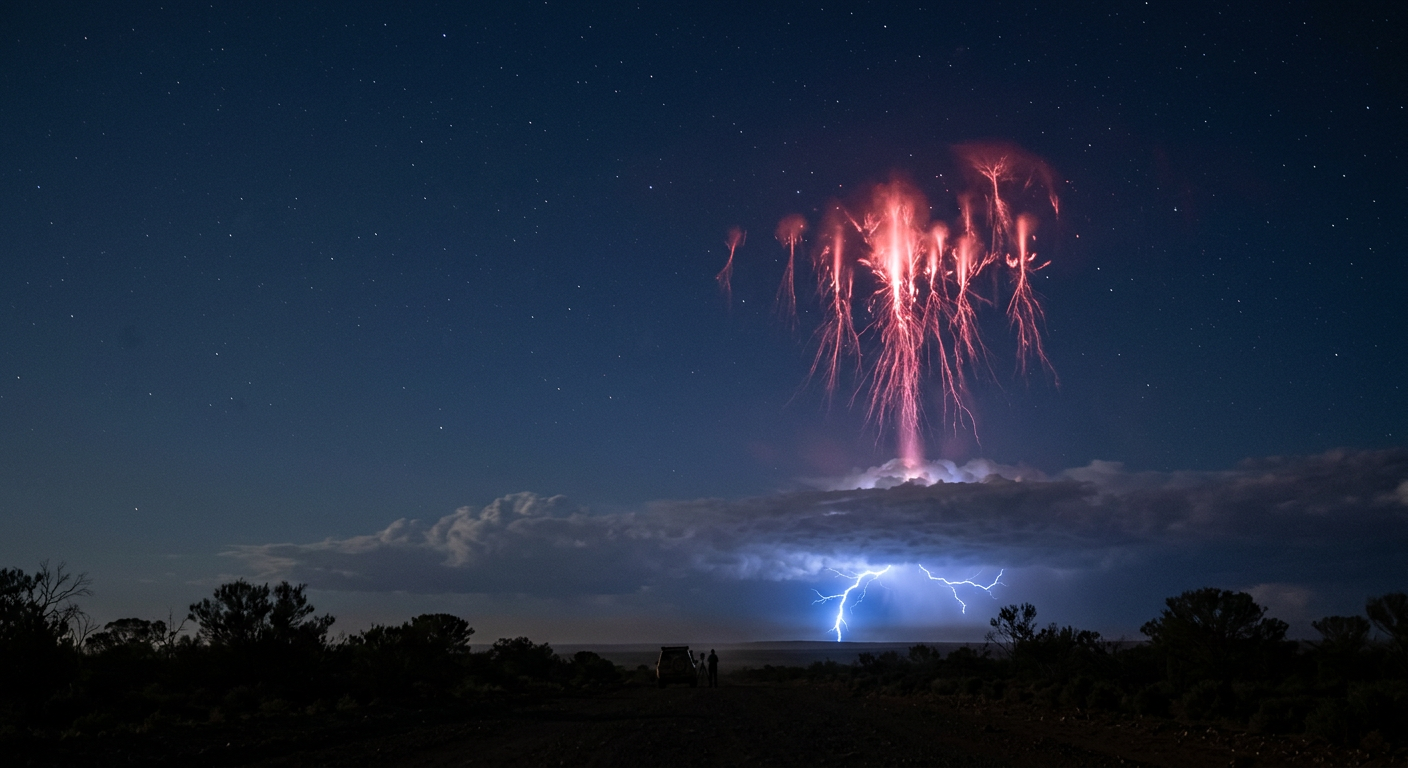
Red sprites are among the most fascinating upper-atmospheric lightning phenomena documented by meteorologists. Unlike the familiar bright flashes of tropospheric lightning that strike the ground, red sprites occur far above the storm clouds. They manifest as cold plasma discharges in the mesosphere, a region of the atmosphere that is notoriously difficult to study.
Because the mesosphere is too high for weather balloons and too low for typical satellites, understanding the layers of the atmosphere is essential for mapping where these electrical discharges take place. Global meteorological databases officially recognise them as transient luminous events rather than standard lightning.
What is red sprites lightning?
Red sprites lightning refers to large-scale, high-altitude electrical discharges that occur in the mesosphere above active thunderstorms. These transient luminous events are triggered by intense positive cloud-to-ground lightning strikes, which create a massive electrical imbalance that ionises the atmosphere at altitudes of 50 to 90 kilometres.
The historical discovery of mesospheric optical phenomena
These mesospheric optical phenomena were reported visually by pilots as early as 1886. However, they remained largely unverified anecdotes until their earliest documented photographic capture in 1989 (en.wikipedia.org).
Researchers from the University of Minnesota were testing a low-light television camera when they accidentally recorded dual upward flashes originating from a distant storm system. Since that breakthrough, researchers have identified several structural forms of the red sprite cluster, commonly categorised by their visual shapes as jellyfish, column, and carrot sprites.
The glowing red-orange colour results from the electrical discharge interacting with nitrogen gas in the thin upper atmosphere. As the nitrogen molecules become excited by the sudden surge of electrical energy, they emit light predominantly in the red portion of the visible spectrum.
Explaining the difference between standard storm strikes and red sprites lightning requires looking at the physical state of the discharge. While normal lightning is a hot plasma channel that can reach temperatures hotter than the surface of the sun, sprites are a cold plasma phenomenon. They share more physical similarities with the electrical discharge seen inside a fluorescent light tube than they do with a superheated tropospheric lightning bolt.
Identifying sprites with high-speed cameras
Because sprites typically last between 10 and 100 milliseconds, they are nearly impossible to study with standard video equipment. A standard camera recording at 30 frames per second will capture the entire lifecycle of a sprite in a single frame, resulting in a blurry, structureless red smudge.
Modern meteorological research relies on advanced high-speed cameras capable of recording thousands of frames per second to break down their exact structural evolution.
Institutions such as the University of Alaska Fairbanks use these high-speed camera arrays to dissect the exact sequence of a sprite event. High-speed footage reveals that a sprite does not simply flash into existence all at once.
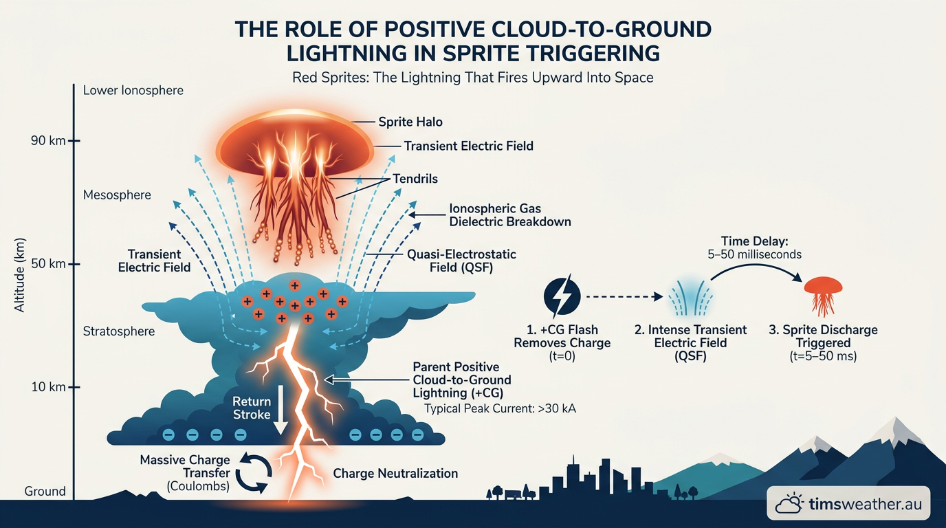
Instead, it begins as a small ionised halo at about 75 kilometres in altitude. From this halo, bright downward tendrils shoot rapidly toward the cloud tops, followed milliseconds later by upward branches extending toward the ionosphere. This complex structural evolution proves that transient luminous events are dynamic plasma formations reacting to extreme atmospheric conditions.
How do red sprites form above thunderstorms?
To understand why red sprites fire upward, meteorologists must examine the severe weather systems that produce them. Sprites are entirely dependent on the thunderstorm activity occurring tens of kilometres below them in the troposphere.
They most frequently appear above large mesoscale convective systems, which are massive, long-lasting clusters of thunderstorms that can span hundreds of kilometres. Watching how low-pressure systems form and evolve into these severe nocturnal storm complexes is the first step in forecasting potential sprite activity.
The Role of Positive Cloud-to-Ground Lightning in Sprite Triggering
The primary trigger for a red sprite is an exceptionally powerful positive cloud-to-ground lightning strike. The vast majority of ordinary lightning strikes are negatively charged, transferring negative charge from the lower portion of the storm cloud directly to the ground.
Positive strikes, however, originate from the positively charged upper levels of the storm anvil. When atmospheric conditions allow for these strikes, they release tremendous energy, validating historical records of electrical flashes associated with the most severe storms (www.almanac.com).
When a massive positive lightning bolt discharges to the surface, it suddenly removes a massive amount of positive charge from the upper reaches of the storm system. You can review how cloud-to-ground lightning forms to see how charge separation builds within a cumulonimbus cloud. This rapid transfer creates an enormous, temporary electrical imbalance in the atmosphere directly above the storm, setting the stage for mesospheric breakdown.
The Physics of Ionospheric Discharge Explained
The sudden absence of charge below creates an intense quasi-electrostatic field that extends high into the mesosphere. If this electric field is strong enough, it accelerates free electrons in the thin air upwards.
These fast-moving electrons collide with nitrogen molecules, causing an effect known as a Townsend avalanche, where collisions free more electrons in an exponentially growing chain reaction. The atmospheric pressure at 50 to 90 kilometres is extremely low, meaning electrical breakdown occurs much more easily than it does near the surface of the Earth.
This low-pressure environment allows the red sprite cluster to expand over a massive volume of space, sometimes stretching up to 50 kilometres across. The entire event is exceptionally brief, typically lasting less than 20 milliseconds before the local electric field relaxes and the light fades back into the darkness of the upper atmosphere.
Because the density of the atmosphere dictates how electricity moves through it, the physical dimensions of these flashes are directly tied to the precise altitude at which the electrostatic field peaks.
Atmospheric chemistry and the Global Electric Circuit
Red sprites are not isolated visual curiosities. They are deeply connected to the Global Electric Circuit, a continuous flow of electricity between the Earth's surface and the ionosphere maintained primarily by global thunderstorm activity.
As thunderstorms pump electrical current into the upper atmosphere, transient luminous events serve as temporary, high-energy conductive pathways that help regulate this global charge balance. Observing these events helps meteorologists map the massive flow of electrical energy escaping from the troposphere into space.
Why Mesospheric Chemistry Matters for Global Climate Monitoring
Beyond their electrical role, these high-altitude discharges significantly impact atmospheric chemistry. When sprites and other transient luminous events ionise the mesosphere, they facilitate chemical reactions that would not otherwise occur in that cold, thin environment. One major consequence is the production of nitrogen oxides.
The energetic collisions that excite nitrogen molecules also break their chemical bonds apart, allowing the free nitrogen atoms to bond with available oxygen to form nitric oxide. This process is extensively documented in scientific studies conducted from platforms situated at approximately 400 kilometres in altitude (www.geographyrealm.com).
Nitric oxide production in the upper atmosphere is an active area of climate research because these molecules can eventually descend into the stratosphere. Once in the stratosphere, nitrogen oxides are known to participate in chemical cycles that contribute to ozone depletion.
By mapping the frequency and intensity of red sprites, atmospheric chemists can better estimate the volume of nitrogen oxides being generated above major storm systems worldwide. Space weather agencies and meteorological institutions frequently share this interdisciplinary data to refine their global atmospheric chemistry models.
Distinguishing Red Sprites from ELVES and Blue Jets
Red sprites belong to a broader family of upper-atmospheric weather phenomena known as transient luminous events. While sprites are the most commonly documented, several other forms of ionospheric discharge share the skies above active thunderstorms. Learning to differentiate these events helps observers categorise the many types of lightning and related electrical phenomena in our atmosphere. Other well-documented transient luminous events include blue jets, ELVES, trolls, and gnomes.
Comparison of Transient Luminous Events (TLEs)
Phenomenon | Altitude Range | Typical Color | Duration |
|---|---|---|---|
Red Sprites | 50 to 90 km | Red-orange | 10 to 100 milliseconds |
Blue Jets | 15 to 50 km | Blue | 100 to 200 milliseconds |
ELVES | 90 to 105 km | Dim red | Less than 1 millisecond |
Trolls | Below 70 km | Red | Up to 150 milliseconds |
Sprites and ELVES
ELVES (Emissions of Light and Very Low Frequency perturbations due to Electromagnetic Pulse Sources) are another distinct upper-atmospheric phenomenon. ELVES appear as rapidly expanding, enormous, flat rings of reddish light at the very base of the ionosphere, approximately 90 kilometres above the ground.
Unlike sprites, which are driven by the quasi-electrostatic field left behind after a lightning strike, ELVES are generated by the intense electromagnetic pulse released by the initial lightning discharge itself. These powerful pulses travel upward at the speed of light, briefly illuminating a wide ring in the ionosphere as they pass through.
The distinct formation of blue jets
Blue jets differ from sprites in both colour and origin. While sprites form in the mesosphere and propagate downwards, blue jets shoot directly upwards from the top of the cumulonimbus cloud into the stratosphere, sometimes reaching 50 kilometres in altitude.
They appear as bright, narrow cones of blue light and are thought to be related to intense electrical mixing and heavy hail activity within the central storm core. Exploring how intra-cloud lightning forms reveals why lower-altitude storms require intense, hot plasma channels instead of the faint, cold plasma glows seen higher up in the mesosphere.
Observing Transient Luminous Events from Low Earth Orbit
Studying red sprites from the ground is notoriously difficult. The mesosphere sits directly above severe thunderstorms, meaning the massive cloud decks that generate the sprites physically block the view from directly below. Also, the lower atmosphere scatters light and introduces moisture and haze, which obscure faint optical phenomena. This is why some of the most critical data on sprites comes from above.
The International Space Station ASIM mission
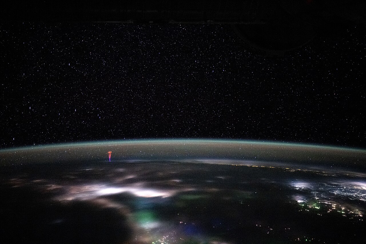
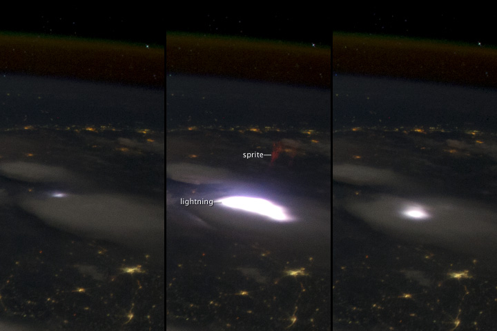
Satellites and spacecraft can observe the mesosphere from above the cloud tops, providing an unobstructed downward view. The European Space Agency's ASIM (Atmosphere-Space Interactions Monitor) mission, mounted on the outside of the International Space Station, is specifically designed to hunt for transient luminous events.
Using highly sensitive optical sensors and X-ray detectors, ASIM captures sprites with incredible precision. This matches the distinct imagery recorded by NASA astronauts from low Earth orbit over regions spanning Mexico and the United States (www.reddit.com).
That high vantage point matters because a space platform can capture the full upper-storm environment in one frame, including the lightning flash below and the red glow above. This helps researchers directly link the precise location and timing of the mesospheric discharge to the specific thunderstorm cell that triggered it.
Astronauts frequently monitor these events during their shifts on the space station, gathering vast archives of data that allow scientists on the ground to track precisely how often these immense electrical discharges occur worldwide.
Where to look for red sprites globally
For weather enthusiasts hoping to see red sprites from the ground, specific conditions are strictly required. Because the flashes are extremely brief and relatively faint, they cannot be seen during daylight. Observers require a fully dark sky, completely free of light pollution, and a clear, unobstructed view toward a distant, severe thunderstorm.
You must be far enough away from the storm to see the sky above the cloud tops, typically between 100 and 300 kilometres away from the active lightning core. Modern observers often rely on an understanding of cloud types and weather forecasting to predict where clear air will abut a major severe weather outbreak.
Major global hot spots for sprite activity
Photographers frequently point their low-light cameras toward major nocturnal storm complexes around the world. Prime locations include the midwestern United States, southern Europe, South Africa, and East Asia, where massive mesoscale convective systems frequently develop during the summer months.
There is also extensive documentation captured above thunderstorms in Puerto Rico, proving that coastal and island-based storms can also trigger the necessary positive lightning strikes (www.youtube.com). Extensive storm chasing teams in regions like the highveld of South Africa also regularly capture upward-firing lightning systems on clear nights (www.youtube.com).
Observers typically use wide-angle, fast lenses set to continuous shooting or high frame-rate video to ensure they do not miss the millisecond flash. While seeing them with the naked eye is exceedingly rare, experienced storm chasers occasionally spot brief red flickers out of the corner of their vision when watching distant lightning. These faint glimmers above the clouds confirm that the upper atmosphere is alive with electrical activity, continuing the ongoing scientific fascination with transient luminous events. Whether you are charting high and low pressure systems to locate a severe storm corridor or configuring a specialized low-light camera, mapping the detailed electrical behavior of our atmosphere remains a compelling field for both meteorologists and amateur scientists alike.
Sources
Spectacular 'nature's neon lights' caught on camera over WA outback (abc.net.au)
CSIRO atmospheric science reference (publications.csiro.au)
Victorian Heritage Database (guides.slv.vic.gov.au)
CSIRO atmospheric science reference (publications.csiro.au)
The AIATSIS Collection (aiatsis.gov.au)
NOAA weather and atmospheric science reference (nssl.noaa.gov)
International Cloud Atlas (cloudatlas.wmo.int)
Sprites may play role in Earth's climate (abc.net.au)
Last verified: 2026-09-24
Frequently asked questions
Red sprites are brief, reddish flashes occurring high above thunderstorms. Unlike ordinary cloud-to-ground lightning, they are transient luminous events caused by electrical activity in the upper atmosphere. Because they last only a few milliseconds, they are incredibly difficult to spot with the naked eye and require specialised equipment.
Source: en.wikipedia.org
Further reading and resources
Explore trusted articles, books, videos and other resources to go deeper on this topic.
nationalgeographic.comArticle
The most otherworldly, mysterious forms of lightning on Earth
In-depth coverage on Red Sprites: The Lightning That Fires Upward Into Space from nationalgeographic.com.
plus.nasa.govReference
Chasing Sprites in Electric Skies - NASA+
Background reference on Red Sprites: The Lightning That Fires Upward Into Space from plus.nasa.gov.
geographyrealm.comArticle
Red Sprites and Blue Jets: Electrical Storms in the Upper Atmosphere
In-depth coverage on Red Sprites: The Lightning That Fires Upward Into Space from geographyrealm.com.
youtube.comVideo
What Is a Sprite? Earth's Super Rare Red Lightning Explained - YouTube
Video coverage on Red Sprites: The Lightning That Fires Upward Into Space from youtube.com.
What is this 'red lightning' shooting into space? - YouTube
Video coverage on Red Sprites: The Lightning That Fires Upward Into Space from youtube.com.
science.nasa.govReference
Red Sprites Above the U.S. and Central America - NASA Science
Background reference on Red Sprites: The Lightning That Fires Upward Into Space from science.nasa.gov.
paulmsmithphotography.comArticle
What are red sprites, blue jets, and other Transient Luminous events?
In-depth coverage on Red Sprites: The Lightning That Fires Upward Into Space from paulmsmithphotography.com.
earthweb.ess.washington.eduReference
Red Sprites Info - UW ESS
Background reference on Red Sprites: The Lightning That Fires Upward Into Space from earthweb.ess.washington.edu.
en.wikipedia.orgReference
Sprite (lightning) - Wikipedia
Background reference on Red Sprites: The Lightning That Fires Upward Into Space from en.wikipedia.org.
almanac.comArticle
Red Sprites, Blue Jets, Elves, and Lightning Storms
In-depth coverage on Red Sprites: The Lightning That Fires Upward Into Space from almanac.com.
Planning weeks ahead?
Check Australia's long-range seasonal outlook for rainfall, temperature and the climate drivers (ENSO, IOD, SAM, MJO) shaping the next three months.
View Australia's Seasonal Weather Forecast